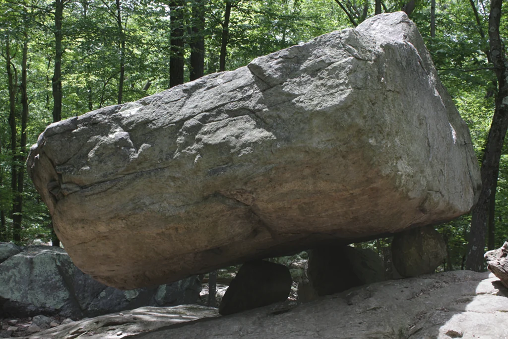
Tripod Rock (2019) — photo by Brian W. Schaller, Free Art License 1.3.
Glacial geology
A boulder on three stones
Tripod Rock is a glacial erratic — a balancing rock left perched when the last ice sheet melted away. The boulder is Precambrian gneiss, roughly 6 meters (20 ft) long, 3 meters (10 ft) wide, and 2.5 meters (8 ft) high, and it rests on three much smaller stones about a meter across that lift it clear of the bedrock. Where the boulder touches its supports, the contact points form an almost perfect 3-4-5 triangle.
Its weight is usually given as roughly 160 tons, with estimates ranging from about 140 to 180 tons; the published geological figure is about 127 tonnes (~140 U.S. tons, ~280,000 lb). The exact number depends on how the rock's volume is estimated. However it is measured, it is one of the most striking balanced erratics in the New Jersey Highlands.
Local history
Older signs and local retellings put Tripod Rock at 'close to 160 tons,' and some accounts go to 180. The published geological estimate is about 127 tonnes (~140 U.S. tons) — we cite the range rather than pick a single number the record doesn't fix.
~18,000 years ago
How the ice left it here
During the last glaciation, the Wisconsin ice sheet ground south across these highlands, carrying rock for miles before it stalled and melted back roughly 18,000 years ago. As the ice wasted away it set its load down wherever it happened to be — sometimes, by chance, balancing a massive boulder on smaller stones beneath it. That is the mechanism geologists credit for Tripod Rock: not design, but the patient accident of a melting glacier.
The legend
Local lore
“New Jersey's Stonehenge”
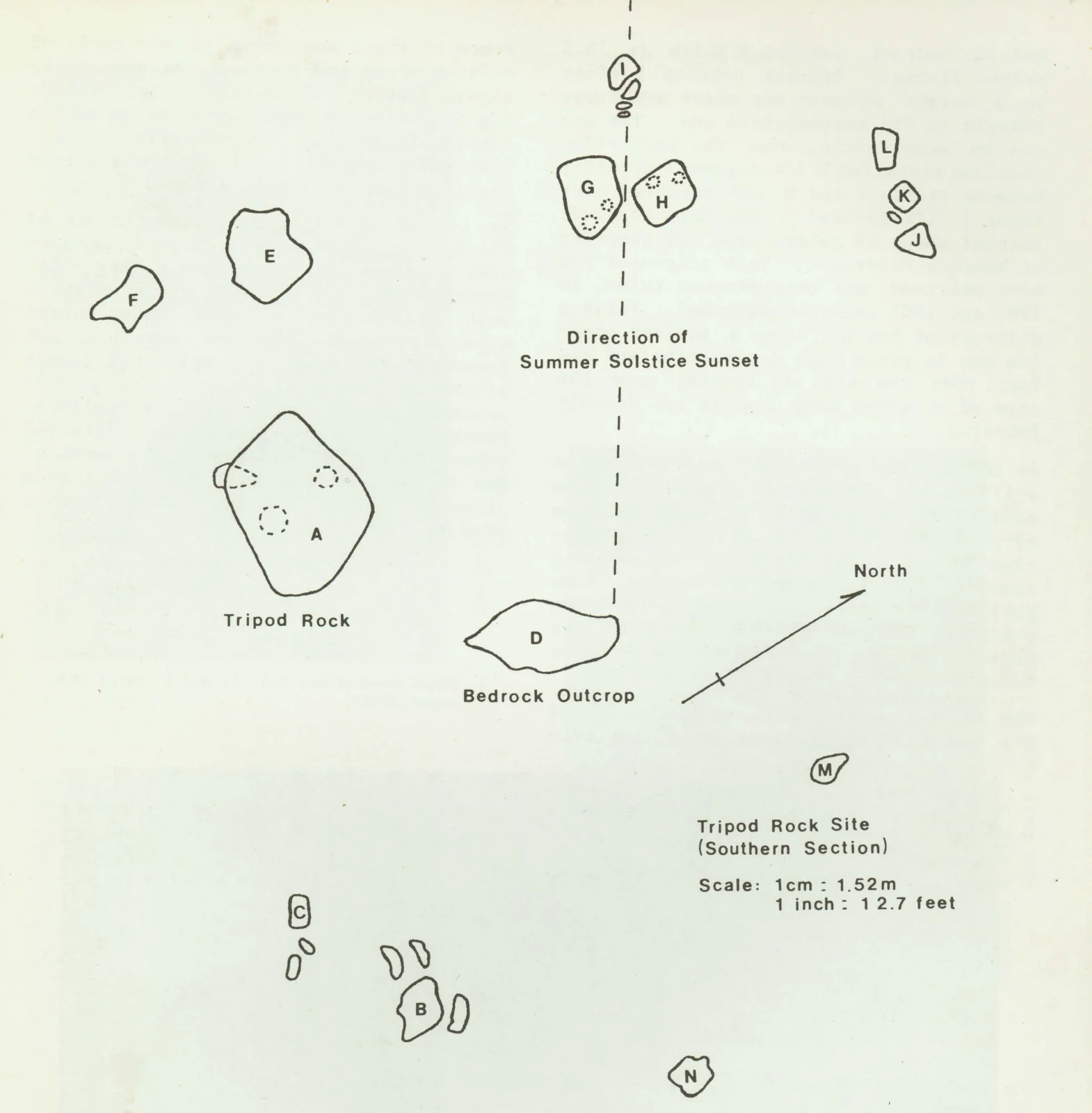
Tripod Rock's drama has long invited a second story. In the early 1980s the writer and astrologer Bruce Scofield surveyed the boulder cluster — about 39 feet northwest of Tripod Rock, three more boulders form a triangle — and argued that, sighted past the two larger stones, the rock frames the sunset at the summer solstice on the far ridge. In this telling it is a deliberate Native American calendar site, “New Jersey's Stonehenge.” (The sightline was briefly easy to trace because a gypsy-moth defoliation had thinned the canopy that year.) The idea took hold; some visitors go further still, describing the spot as a place of spiritual energy, and many climb to the rock at the solstice to see for themselves.
It is a wonderful story, and it belongs to the mountain. But it is lore, not established fact — offered here as the tradition it is, beside the geology.
Documented
The reference encyclopedia entry for Tripod Rock states plainly that “no specific calendar alignment has been noted,” and a CUNY geography page calls the archaeological reading “probably wishful thinking.” As one geologist notes, no technology of the era could have lifted the boulder — so the leading view is that people revered a striking natural feature (perhaps adding the smaller stones nearby), not that they engineered it. Mainstream geology attributes the boulder and its companions to glacial deposition.
A marker half-lost
Local history
What development nearly cost
There is a poignant footnote to the solstice story. Within about a year of the 1980s survey, a house was built on the very ridge where the solstice sun was said to set, and earth-moving machinery displaced one of the marker boulders — so today the alignment can be seen only in part. It is a small, concrete emblem of exactly the development pressure that, a few years later, drove neighbors to save the rest of the mountain.
Getting there
Tripod Rock is on the Kinnelon side of the park, on a ridge above the valley where Bear Rock sits. The most popular approach is the Morris County “Tripod Rock” suggested hike from the visitor center; the route and current blaze colors are on the official trail map. It is a rocky, rooty climb — hiking shoes and the official map are both worth bringing.
Tripod Rock area survey — Bruce Scofield, public domain.
The solstice survey
What the survey actually showed
Bruce Scofield's 1980s diagram of the Tripod Rock cluster mapped the boulders and the sight line he proposed for the solstice sunset. It is the source of the “calendar site” claim — a careful piece of amateur archaeoastronomy that remains unconfirmed by geologists, who see the same stones as the glacier's handiwork.
“A glacier balanced it; a legend lifted it; the truth is wonderful either way.”