The icon
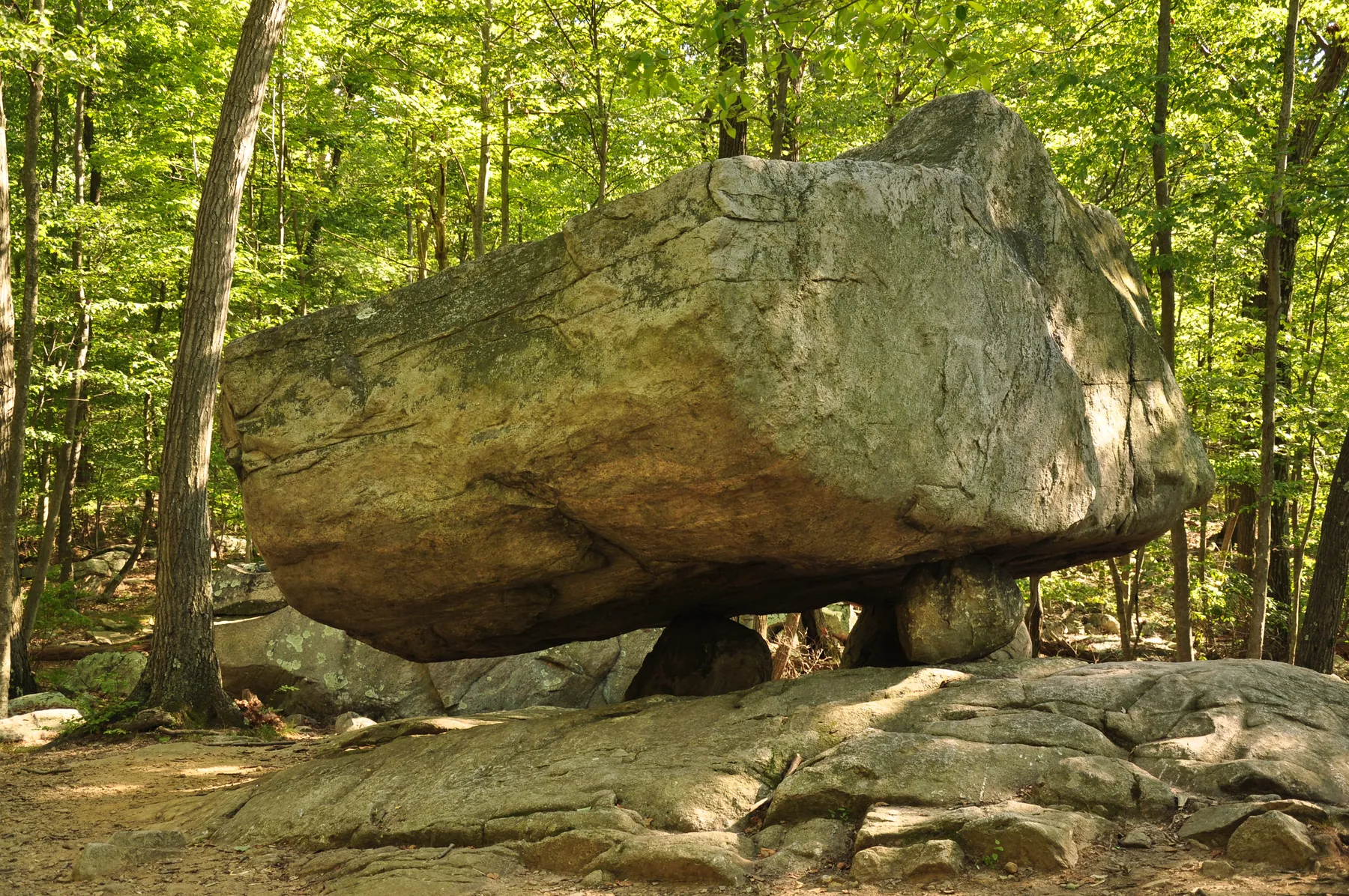
Tripod Rock
The ~127-tonne erratic on three stones — and the solstice legend, told honestly.
Glaciers, outlaws, and the fight to save it.
Tripod Rock, Pyramid Mountain — photo by Steven Reynolds, CC BY 2.0.
Explore Pyramid Mountain
The icon
The ~127-tonne erratic on three stones — and the solstice legend, told honestly.
Its companion
One of NJ's largest erratics, brooding over a swamp near old stone walls.
The other ridge
The park's quieter half, across Boonton Avenue — and the steep "100 Steps."
The fight to save it
Lucy Meyer, a grassroots committee, and the coalition that bought a mountain.
Ruins & lore
Cabin ruins on the western trail — and the legend of the Tar Rope Gang.
On foot
The current official Morris County trail roster — blazes, distances, terrain.
Plan a visit
Hiking, glacial geology, birding, the NYC-skyline overlook, the visitor center.
At a glance
The Pyramid Mountain Natural Historic Area spreads over 1,600 acres of rugged Highlands ridge and swamp where Kinnelon meets Montville and Boonton Township in Morris County, New Jersey. It is hiking-only — no bikes, no rock climbing — with more than 19 miles of trails managed by the Morris County Park Commission, a visitor center at 472 Boonton Avenue, and a 934-foot high point that, on a clear day, looks east to the Manhattan skyline.
What draws people up the mountain are the glacial erratics: house-sized boulders the last ice sheet carried here and left behind. Tripod Rock, Bear Rock, and Whale Head Rock are the famous three. The land around them was nearly lost to development in the 1980s and saved by a grassroots campaign — the story this section tells, alongside the deeper one written in ice and stone.
The park today
DocumentedThe Natural Historic Area straddles three municipalities — Kinnelon, Boonton Township, and Montville — with roughly 211 of its acres lying within Kinnelon and Tripod Rock itself on the Kinnelon side. It takes in two ridges: Pyramid Mountain on the west and Turkey Mountain across Boonton Avenue (Route 511) to the east. Alone among the Morris County parks, it is hiking-only — no bikes — which is part of why its trails feel so quiet.
The land is a patchwork of Morris County Park Commission and New Jersey state (DEP) ownership, and the trail network is built and maintained by the volunteer New York–New Jersey Trail Conference. Beyond recreation, the mountain does quiet ecological work: its ridges and valleys feed downstream reservoirs and aquifers, and it shelters plants and animals uncommon in New Jersey, including state-listed threatened and endangered species.
Roughly 18,000 years ago, the retreating Wisconsin Glacier dropped its load of rock across these highlands as a terminal moraine. The boulders it left behind — glacial erratics, carried from miles away and stranded as the ice melted — are what make Pyramid Mountain famous.
The best known is Tripod Rock — sometimes called “Morris County's Stonehenge”: a boulder of close to 160 tons that sits, improbably, atop three much smaller stones. Some believe early Native people set it as a solstice marker or calendar site; geologists credit the glacier, which can leave erratics balanced just so. Either way, it has drawn the curious for generations.
Nearby stand its companions. Bear Rock — one of the largest glacial erratics in New Jersey — broods over a swamp near the Kinnelon–Montville line and is said to have sheltered Native people passing through. Whale Head Rock, breaking from the ridge like a surfacing whale, rounds out the trio.
Before the survey lines
Local historyLong before any of these ridges carried blazes, the Highlands were Lenape country — the Munsee-speaking people of the Lenape whose paths, fishing places, and seasonal camps ran through the Pequannock valley for more than ten thousand years. The river name itself is Lenape: "Pequannock" is generally read as "cleared land" or "open ground." A Native American site at Pyramid Mountain is documented in the Anthropological Papers of the American Museum of Natural History and was catalogued in Lucy Meyer's resource inventory of the mountain — a thread of evidence for how long people have used this exact ground.
Later came the colonial surveyors. The mountain fell within the great highland tracts laid out in the 1700s, and the woods are still seamed with their work: low fieldstone walls that once divided woodlots and pastures, and the occasional cut survey stone marking a corner. Walking the trails, you cross from Lenape ground to colonial farm boundary to county park, all on the same slope.
How heavily the Lenape used Tripod Rock itself — as a marker, gathering place, or sacred site — is cherished tradition rather than settled fact. The boulders are the glacier's work; what people made of them is a story told with more feeling than evidence.
In colonial times the mountain lay within the Great Boonton Tract, a large highlands holding said to have been surveyed in part by William Penn. For two centuries afterward it was working land — woodlots, charcoal, and scattered farms on thin mountain soil.
Local lore holds that the Morgan brothers — a pair of Boonton outlaws, or simply troublemakers — hid out on the mountain in the 1800s. The stone remnants known as the “Ruins of the Morgan Place” still stand along a western trail; how much of the legend is true is anyone's guess.
In the 1920s, during America's great electrification, tall steel towers and transmission lines were strung across the mountain — the first heavy mark of the modern grid on a landscape that had changed little in centuries.
When the completion of Interstate 287 set off a Morris County building boom, developers proposed homes on the privately held land around Tripod Rock by the mid-1980s. Kinnelon's Lucy Meyer — the first woman engineer at Sperry Gyroscope, and a local historian and environmental commissioner — and her husband Karl rallied neighbors into the grassroots Committee to Save Pyramid Mountain. (An earlier Meyer campaign had saved a butternut tree thought to be the largest in the state — now pictured on the Kinnelon town seal.) President Reagan honored the effort with a “Take Pride in America” award on the White House lawn in July 1988, and a wave of land purchases by state, county, and local government soon created the Pyramid Mountain Natural Historic Area — roughly 1,500 acres across Kinnelon, Montville, and Boonton, managed by the Morris County Park Commission. A visitor center and the lookout named “Lucy's Overlook” carry the story forward; Lucy Meyer died in 2019, at 89.
The trailblazer
The first woman engineer at Sperry Gyroscope, a local historian, and Kinnelon's environmental commissioner, Lucy Meyer (1930–2019) led the grassroots fight to save Pyramid Mountain in the 1980s. Her campaign earned a national “Take Pride in America” award from President Reagan in 1988, and the overlook on the mountain now bears her name.
“A mountain saved not by a law, but by neighbors who would not let it go.”
From the community
Knowledge of this place lives in its families. If you can add a story, correct a detail, or bring forward a name still waiting to be told, we'd be honored to include it. Every submission is read before it's published.
Your turn
A story, a correction, or a name we've missed — every piece helps. It takes a minute.
Visit this place
Pyramid Mountain & Tripod Rock
The Pyramid Mountain Natural Historical Area is open to the public; Tripod Rock is a short hike from the visitor center on Boonton Avenue (Route 511).
Sources
Compiled from publicly available sources; where accounts differ, the most widely documented version is used. Community corrections welcome.
Explore more of the Highlands