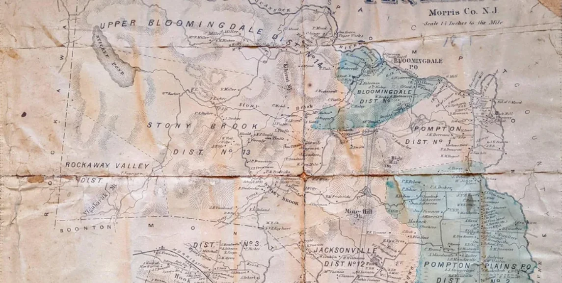
Lenape ground, iron furnaces, Dutch farms, a cigarette magnate's estate, and finally a borough — the people whose names still mark this map.
Pequannock Township, from F.W. Beers' Atlas of Morris County, 1868 — the farms and family names of the land that became Kinnelon. Public domain.
Before Kinnelon was a borough it was farmland, and before that it was iron country, and before that it was Lenape ground. The families on this page cleared it, mined it, farmed it, and finally incorporated it — and many of their names still sit on the map: Meadtown, Ricker Road, Stickle Pond, Lake Kinnelon. This is their story, told from the sources and honest about what the record does and does not prove.
Before the deeds
Local history
The land and the Lenape
Long before any surname was written on a deed, these misty ridges were Lenni-Lenape country. The word Pequannock — the river, and the township that would govern this land for almost two centuries — comes down from their language, and the name Smoke Rise carries a translation of the Lenape name for these mountains, for the way the morning fog lifts off them like smoke. The families in this history arrived on land that already had names; the deeds came later.
Documented
That “Smoke Rise” renders the Lenape name for the misty mountains, and that “Pequannock” descends from the Lenape, is documented in the encyclopedic record.
1740
Documented
Pequannock Township
In 1740 the colony carved out Pequannock Township, a vast original Morris County township that once held Butler, Pompton Plains, Riverdale, Montville, and these highlands together along the Pequannock River valley. For nearly two centuries the land that became Kinnelon was simply a remote upland corner of Pequannock — which is exactly why the 1868 atlas that maps these farms is a Pequannock plate, not a Kinnelon one.
Research in progress
Some accounts place European settlers on the west bank of the Pequannock as early as around 1710; that detail traces to an unreliable source and is not asserted here.
1760s–1820s
Documented
The iron families
The first industry these highlands knew was iron. In 1765 the German ironmaster Peter Hasenclever built the Great Charlotteburg furnace for the London-based American Company, naming the tract for Queen Charlotte, wife of King George III; charcoal furnaces and iron mines worked the land along the Pequannock River. Among the families who worked that iron, the Deckers are remembered for running a local forge. When the Morris Canal arrived in the 1820s and the cheaper transport it promised reshaped the iron trade, the Charlotteburg boom faded, and the highlands turned to farming.
Local history
Local history holds that ironmaster Robert Erskine — George Washington's surveyor — raised the first organized militia in New Jersey at these works; it is a cherished local claim rather than a settled one.
1800s
Documented
The farming families
With the iron gone, Dutch and German farm families settled the valley, and it is their names that still mark it. The Meads gave their name to Meadtown, where a one-room schoolhouse was built in 1839 below the Mead house and served the district until a new schoolhouse replaced it in 1873 — and it is that 1873 building, not the first, that later became L'Ecole and stands today as the Kinnelon Museum. The Rickers farmed nearby and are remembered in Ricker Road and Lake Rick-A-Bear; the Deckers stayed on; and the Stickles — descended from an early German settler who reached the valley shortly before the Revolution — left their name on Stickle Pond, the old name for Lake Kinnelon. By 1887 the families recorded on this land included the Smiths, the Millers, the Rickers, the Deckers, and the Meads.
Local lore
Family tradition holds that the Meads received a 17th-century “Queen Anne grant” and an 18th-century “King George III grant” of some 5,000 acres. These grants have never been documented — the local historian who recorded the tradition flagged the gap himself — so we present them as cherished lore, not fact.
1880s–1920s
Documented
The Kinney estate
In the 1880s the New York cigarette magnate Francis S. Kinney began assembling a mountain estate of roughly 5,000 acres around Stickle Pond — which he renamed Lake Kinnelon — and on an island in that lake he raised the 1886–1889 St. Hubert's Chapel, later recognized as Louis Comfort Tiffany's first liturgical commission. When the borough incorporated, it took the family's name; Kinney's son Warren became its first mayor, while his son Morris Kinney lived on the estate and, at his death in 1945, left it to his friend John Talbot Sr. The estate would later become Smoke Rise.
Local history
Local history records the estate as 45 separate parcels of ten to six hundred acres, acquired between 1885 and 1920 per a 1920 Newell Harrison survey. A once-published claim that Kinney bought the land from Hubbard Stickle was publicly retracted for lack of any record, and is not asserted here.
1922
Documented
Birth of the borough
On February 20, 1922, the Kinnelon section finally broke away from Pequannock Township and incorporated as its own borough — a community of only about four hundred people, taking its name from the Kinney family. The next year, in 1923, a native-stone school rose on Kiel Avenue, replacing the old one-room Meadtown and Brook Valley schoolhouses that had taught the valley's children for generations. Milton Untermyer — a name local records also render “Untemeyer” — was among the residents who pressed for the new borough.
1920s→
Documented
The lake communities
The borough's modern shape was drawn by water. In 1925 the real-estate developer Frank Fay Jr. and his son Frank Fay III bought 240 acres and laid out a summer lake colony they called Fayson Lakes — “Fay” plus “son” — adding East Lake in 1931 and South Lake in the 1950s. In the 1950s the former Kinney estate itself opened to members as Smoke Rise. The farms had become neighborhoods, but the founding names stayed on the map.
The families, one by one
Each family has its own page — the documented story, the marks they left on the map, and an open invitation to add what you know. Built to be filled in by the people who carry the name. Is this your family? Add a photo or a story.
The families above have their own pages; these are the others the documented record names — drawn only from sourced material, with trades, homesteads, and connections shown where a source documents them and left out where one doesn't. Each is a candidate for its own page as its story is filled in. Expand a family to see its full entry.
1695 — settlementDocumented
Arent Schuyler (1662–1730)
fur trader
surveyor
merchant
land speculator
The Dutch-born fur trader and surveyor whose 1695 Pompton purchase first drew these highlands into colonial New Jersey.
Arent Schuyler was a Dutch-born fur trader, surveyor, and merchant who led the 1695 purchase of the Pompton/Pequannock patent — buying the land first from the Lenape and then from the East Jersey Proprietors. That deal opened this corner of the highlands to European settlement two centuries before Kinnelon became a borough. He later operated the Pompton ironworks, tying the family to the iron century that followed.
Homestead & site
Pompton Valley — settled near Wayne / Pompton, not in Kinnelon
Regional — area only
The regional founder of the 1695 purchase, not a Kinnelon resident; his home, the Schuyler-Colfax House, still stands in Wayne.
Connections
The Mead family — Co-investors in the Pompton Valley purchase — John Mead was among Schuyler's partners (with the Mandevilles, Brockholst, Bayard, Berry, and Ryerson).
Charlotteburg — Ran the Pompton ironworks — an early link to the highland iron century told on the Charlotteburg page.
New Jersey Historical Society — Schuyler Family Papers (MG 651)
Schuyler-Colfax House — Crossroads of the American Revolution
Pequannock Township — “Events of the Past”
1600s–1700s — land grantsLocal history
The Cobb family
farmer
landholder
A grant family remembered through the Cobb patent — the land on which the Fredericks built their farm.
The Cobbs held one of the early Proprietor patents in the highlands. Its lasting trace is the Cobb patent itself: the parcel from which the Fredericks family bought the land for their mid-1700s homestead.
Connections
The Fredericks family — The Fredericks built their farm on land bought from the Cobb patent.
Working farmers who raised one of Morris County's oldest stone houses and held the land for nearly two centuries.
Around 1745 the Fredericks raised a random-fieldstone farmhouse — walls some twenty inches thick — above a spring brook that still runs beneath it, and farmed the land for nearly two centuries. A 1795 family inventory records corn and vegetables raised for market alongside cattle, sheep, and horses; in 1785 Peter Fredericks registered his livestock mark, and he served as a Pequannock Township Freeholder in 1793 and as an overseer of the poor. The family graveyard holds graves back to 1745. The house still stands at 6 Duchess Drive in Fayson Lakes, one of the oldest in Morris County. The family eventually sold the farm to the Kitchells.
Trades & products
corn
vegetables
cattle
sheep
horses
Homestead & site
The Fredericks (Haight) House — 6 Duchess Drive, Fayson Lakes
Exact location
NRHP-listed; a private residence today — view from public areas only. (No verified map pin yet.)
Connections
The Kitchell family — Sold the farm and its lake to the Kitchell family in the early 1900s.
Orchardists who worked the old Fredericks farm as an apple orchard, then sold it to Frank Fay in 1925.
The Kitchells held the old Fredericks farm and its lake into the early 20th century, working it as an apple orchard. Around 1925 they sold the roughly 240 acres to the developer Frank Fay Jr. — the sale that created Fayson Lakes.
Homestead & site
The former Fredericks farm — Stony Brook / Fayson Lakes area
Approximate location
The orchard years on the old Fredericks land; no separate homestead pin is documented.
The suffrage poet Alice Duer Miller and her husband Henry, who built a chapel in her memory on Miller Road.
Alice Duer Miller (1874–1942) was a Barnard mathematician, Algonquin Round Table wit, and suffrage poet — author of Are Women People? (1915) and the verse novel The White Cliffs (1940). After her death her husband, Henry Wise Miller, built the chapel of Our Lady of the Magnificat in her memory, dedicated in 1954; the road carries the family name to this day.
Trades & products
Are Women People? (1915)
The White Cliffs (1940)
Homestead & site
Miller Road & Our Lady of the Magnificat
Approximate location
The chapel and road that carry the family name; an exact homestead pin is not documented.
Connections
Miller Road — The road and the chapel that carry the family name — told in full on their own page.
The developer and arts patron who turned the Kinney estate into the Smoke Rise Club in 1946.
John Alden Talbot Sr. — a New York real-estate developer, arts patron, and a founder of Chilton Hospital — inherited the former Kinney estate from his friend Morris Kinney and, rather than carve it into an ordinary subdivision, founded the Smoke Rise Club in 1946, one of the earliest community-club plans in the country.
Homestead & site
Smoke Rise — the former Kinney estate
Approximate location
Connections
The Kinney family — Inherited the estate from his friend Morris Kinney in 1945.
Smoke Rise — Founded the Smoke Rise Club to hold and govern the land.
A Sawmill Road estate owner who helped lead the 1921 push to make Kinnelon its own borough.
Milton Untermyer, owner of a large estate on Sawmill Road, helped lead the 1921 movement to separate this neglected corner of Pequannock Township into the new borough of Kinnelon, incorporated the following year.
Homestead & site
A large estate on Sawmill Road, Kinnelon
Approximate location
Connections
Kinnelon — Helped lead the 1921 incorporation movement that created the borough.
The Prohibition-era owner who dammed Lake Canty and built the stone Casino speakeasy beside it.
John Canty Sr. bought the land that is now Silas Condict County Park, built a larger dam to raise the seven-acre lake that still bears his name — Lake Canty — in 1926, and in 1933 raised the stone clubhouse he called the Casino, a dine-and-dance speakeasy. (The park's namesake, Silas Condict, was a Revolutionary statesman honored by the county — not a Kinnelon family.)
Surnames the 1868 Beers atlas records on the Stony Brook plate. These are roster entries only — no bios or homestead pins yet, and they are not linked elsewhere on the site until cemetery and census sources are added. Trades are shown only where the 1868 business directory documents them.
F. Fredricks· farmer & merchant
W. Gormly· farmer & carpenter
J. H. Freeland· farmer & blacksmith
B. Milner· farmer & puddler
Tintle
Sanders
Decker
Gould
Witty
Ricker
Francisco
Van Zile
Hart
Davenport
Earles
Bott
The oldest family
The Fredericks House
Built around 1745 above a spring brook that still runs beneath it, the random-fieldstone Fredericks farmhouse — now 6 Duchess Drive in Fayson Lakes — is one of the oldest houses in Morris County. The family farmed here for nearly two centuries before selling to the Kitchells, whose 1925 sale to Frank Fay created Fayson Lakes.
Frequently asked
How did Meadtown get its name?
From the Mead family, among the area's earliest farm families. Meadtown's schoolhouse — a first school in 1839, replaced by a larger one in 1873 — became known as L'Ecole, and that 1873 building stands today as the Kinnelon Museum.
Source: Lucy Meyer, Kinnelon: A History; L'Ecole Kinnelon Museum
Who created Fayson Lakes?
The Fay family — the developer Frank Fay Jr. and his son Frank Fay III — who bought 240 acres in 1925 and laid out the summer lake community, its name reading as “Fay” plus “son.”
Source: Fayson Lakes Association
Why is Ricker Road named that?
For the Ricker family, among Kinnelon's early farming families; nearby Lake Rick-A-Bear also carries their name. The fuller family story is one the record only partly tells.
Source: Borough of Kinnelon local history
“Where the future is enriched by the past.”
Is this your family? Help us tell it right.
This history grows with you
Every family on this page has a story the record only partly tells. If you carry one of these names — or know a name that belongs here — share a photo, a memory, a deed, or a correction. Family stories publish as local history (“as remembered by the ___ family”); dated records and documents publish as documented. Nothing is published without review, and nothing is promoted to documented fact without a record.
The Mead family — farm and butternut-tree photos, deeds, lineage
The Decker family — forge records, photos, lineage
The Ricker family — farm photos, the story behind “Rick-A-Bear,” lineage
The Kinney family — estate and chapel photos, family records
The Fay family — early Fayson Lakes and summer-colony photos and stories
The Stickle family — lineage, the German-settler origins, documents
Another founding family (e.g. the Smiths) — your name and your evidence
Your turn
Be the first to add to this history
A story, a correction, or a name we've missed — every piece helps. It takes a minute.